
Have you ever seen those rocks that look like they’ve been bent in half? Well, that’s exactly what’s happened to them. Folding is a geological process that takes place over huge timescales, but because we’re all busy I thought that I’d break it down in a quick, easy to digest slice! It’s time for another bit of Geography, Simplified!
To begin, here is the basic definition of Folding, from that Elephant’s Graveyard that we teachers always tell pupils never to go to: Wikipedia:
“The term fold is used in geology when one or a stack of originally flat and planar surfaces, such as sedimentary strata, are bent or curved as a result of permanent deformation.
Now, if that seems a little wordy that’s because it is, so lets start to break it down: A fold is the result of a bunch of rock bending or curving due to processes in the earth that cause them to change shape.
Nice and simple.
So, time to get a little more complex. Folding usually occurs in sedimentary rocks, rock created by smaller pieces of eroded rock settling together over millions of years to form layers of rock. The deformation that creates folds can happen either before the sediments are fully lithified (made into solid rock) or after they are if the rocks are ductile (changeable, movable, editable) enough to deform without shattering. The main cause of folding is due to “planar movement” where the plane that the rocks is on shifts and moves, causing the deformation in the rocks – this usually happens as a result of the tectonic plates moving and colliding, or isostatic or eustatic changes (more on those in a later post) causing a rise or fall.
Folds have four main parts to them; a rising limb, a falling limb, an axial plane and a hinge zone.
The rising limb is the side of the fold that appears to be moving upward, whilst the falling limb is the opposite, the side that appears to be going down. The axial plane is the line that divides the fold into two parts and separates the two limbs. The area on the surface where the axial plan would be, where the two limbs join is called the hinge zone, much like the hinge of a door, where the two limbs fold and are joined together.
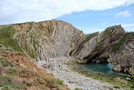
Folds are common in most mountainous areas (known to geographers are orogenic zones) and where there is a large collection of folds on a regional scale, it is called a fold belt. Some examples of folds in the world are at Moruya, New South Wales, Australia and Barstow, California. If you’re looking a little closer to home then the absolutely Wonderful Lulworth Cove in Dorset has a truly fantastic example of folding, particularly at Stair Hole.
So there you go, those weird bendy lines in the rocks have been straightened out a bit! That was Folding, Simplified!
